What is DASOS?
DASOS is an open source software that aims to ease the way of handling the full-waveform LiDAR data. Its name was derived from from the Greek word δάσος (=forest). It was first presented at the International Symposium of Remote Sensing of the Environement, 2015 (Alignment of Hyperspectral Imagery and full-waveform LiDAR data for visualisation and classification purposes). Its last feature was presented at the journal paper Detection of dead standing Eucalyptus camaldulensis without tree delineation for managing biodiversity in native Australian forest.
The aim of this software is to enhance the visualisations and classifications of forested areas using coincident full-waveform (fw) LiDAR data and hyperspectral images. It uses either full-waveform LiDAR only or both datasets to generate metrics understandable for foresters and 3D virtual models.
Influenced by Persson et al (2005), voxelisation is an integral part of DASOS. The intensity profile of each full-waveform pulse is accumulated into a voxel array, building up a 3D density volume. The correlation between multiple pulses into a voxel representation produces a more accurate representation, which confers greater noise resistance and it further opens up possibilities of vertical interpretation of the data. The 3D density volume is then aligned with the hyperspectral images using a 2D grid similar to Warren et al (2014) and both datasets are used in visualisations and classifications.
There are three main functionalities of DASOS:
- the generation of 2D metrics aligned with hyperspectral Images
- construction of 3D polygonal meshes and
- the characterisation of objects using feature vectors.
Aligned Metrics
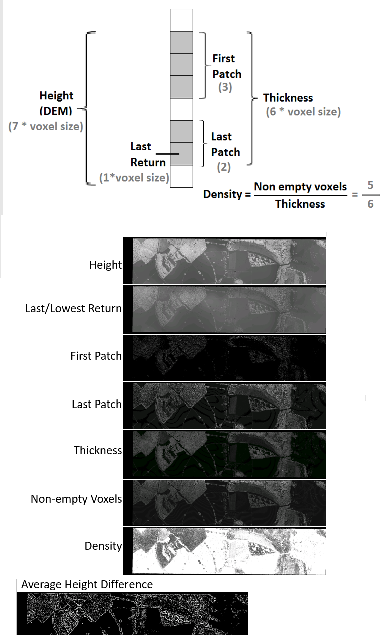
Here is a list of the available metrics:
From FW LiDAR (LAS1.3 or Pulswaves file formats):
– Non-Empty Voxels
– Density
– Thickness
– First Patch
– Last Patch
– Lowest Return
– Average Height Difference (works as an edge detection algorithm)
– AGC intensity
A visual explanation of the available full-waveform LiDAR metrics is given below:
There are also the following Hyperspectral metrics (derived from .bil files & .igm files)
– Hyperspectral Mean
– NDVI
– A single hyperspectral band
More info, please refer to this paper.

Polygonal Meshes
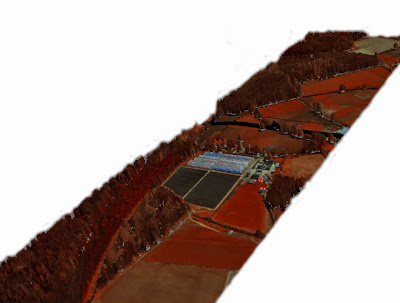
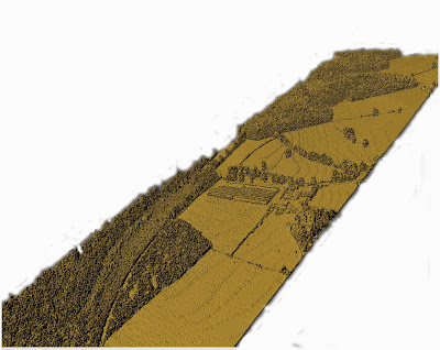
The following example is from New Forest and generated at one meter resolution.The first one was generated using FW LiDAR data and three user defined bands of the hyperspectral images. The second one was generated with only the FW LiDAR data.
The following video was also rendered in Maya using a polygon exported from DASOS:
List of Feature Vectors
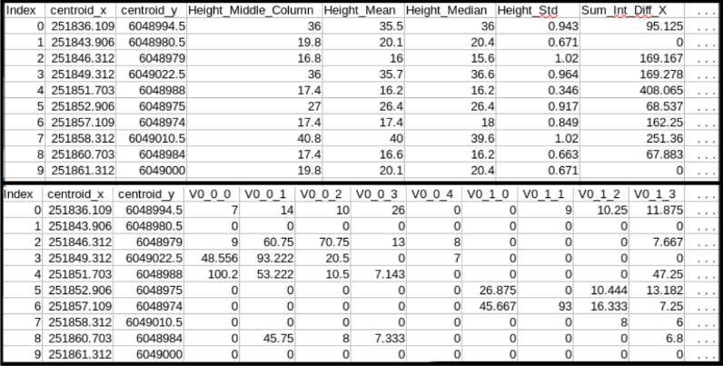
This is useful for characterising object inside the 3D space (e.g. trees). For each column of the voxelised FW LiDAR, information around its local area are exported. The exported format is .csv to easy usage in common statistical packages like R and matlab.
Related Links
The full user guide, the windows executable and the code are available at:
https://github.com/Art-n-MathS/DASOS
To add your own customised 2D metrics, you may read the following tutorial:
http://miltomiltiadou.blogspot.co.uk/2016/07/how-to-add-metrics-to-dasos.html
For any questions regarding the usage of the software please use the following Google Group:
https://groups.google.com/forum/#!forum/dasos—the-native-full-waveform-fw-lidar-software
Updates about DASOS could be found @_DASOS_ on twitter
For more information about the algorithms please refer to the related paper:
Miltiadou M., Warren M. A., Grant M., Brown M., 2015, Alignment of Hyperspectral Imagery and full-waveform LiDAR data for visualisation and classification purposes, 36th International Syposium of Remote Sensing of the Environment.
https://www.researchgate.net/publication/277347868_ALIGNMENT_OF_HYPERSPECTRAL_IMAGERY_AND_FULL-WAVEFORM_LIDAR_DATA_FOR_VISUALISATION_AND_CLASSIFICATION_PURPOSES
Acknowledgements
The DASOS project started as a part of the EngD thesis of Dr Milto Miltiadou, which was funded by the Centre for Digital Entertainement, University of Bath, UK and the NERC Airborne Research Facility, Plymouth Marine Laboratory, UK. This thesis was supervised by Dr Michael Grant, Dr Matthew Brown and Dr Neill D.F. Campbell.